md 0991 concerning severe thunderstorm watch 329... for portions of central/southern indiana...portions of central/northern ohio
mesoscale discussion 0991
nws storm prediction center norman ok
0335 pm cdt wed jun 05 2019
areas affected...portions of central/southern indiana...portions of
central/northern ohio
concerning...severe thunderstorm watch 329...
valid 052035z - 052230z
the severe weather threat for severe thunderstorm watch 329
continues.
summary...ongoing storms in central and northeast ohio have remained
more discrete. damaging wind gusts and a brief tornado will be
primary threats until storms move into more stable environment to
east. linear segments in central indiana will move
southward/southeastward in highly buoyant airmass and continue to
pose damaging wind gusts threat through early evening.
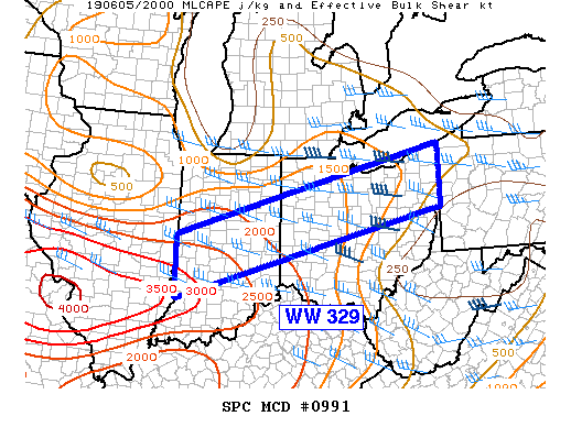
discussion...storms within ww 329 appear to be occurring in two
differing regimes. linear segments in central indiana will be moving
southward into highly buoyant airmass characterized by 2500-3000
j/kg mlcape, per objective mesoanalysis. with the strong heating
that has occurred across southern indiana and north-central
kentucky, this activity will pose the greatest risk for damaging
wind gusts at least until early evening. farther northeast into
ohio, buoyancy has been more limited, but low-level and deep-layer
shear have been marginally higher. storms here have been able to
remain quasi-discrete and exhibit modest low-level rotation. kiln
vad has shown some increase in 1-2 km flow over the past two hours
which has been depicted in guidance into the early evening. as such,
this region is where any brief tornado threat will be maximized this
evening. a few water-loaded downdrafts may also produce a few
damaging wind gusts as well. the environment downstream of the
northern/central ohio thunderstorms is less favorable for continued
severe activity. loss of daytime heating will likely mean a decrease
in storm intensity as they progress eastward.
..wendt.. 06/05/2019
...please see www.spc.noaa.gov for graphic product...
attn...wfo...pbz...cle...iln...iwx...ind...ilx...
lat...lon 40078752 41958049 40668048 38788751 40078752
read more