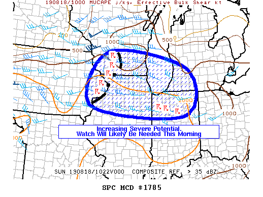
md 1785 concerning severe potential...watch likely for northern illinois...southern wisconsin...southern lake michigan...northern indiana...and southwest michigan
mesoscale discussion 1785
nws storm prediction center norman ok
0544 am cdt sun aug 18 2019
areas affected...northern illinois...southern wisconsin...southern
lake michigan...northern indiana...and southwest michigan
concerning...severe potential...watch likely
valid 181044z - 181215z
probability of watch issuance...80 percent
summary...organized cluster of thunderstorms continue east this
morning across northern illinois and southern wisconsin. a gradual
increase in thunderstorm intensity through the morning should result
in the need for a severe thunderstorm watch at some point this
morning.
discussion...well-organized cluster of thunderstorms is moving east
across southern wisconsin and northern illinois this morning. this
activity is located to the southeast of a mesoscale convective
vortex (mcv) located to the east of minneapolis. despite recent
measured winds being below severe criteria, this cluster of storms
is moving into an increasingly favorable thermodynamic environment,
where most-unstable cape values are around 2500 j/kg. deep-layer
shear is being augmented by the circulation associated with the mcv
and is between 35-45 knots. further destabilization of the
atmosphere is expected with the onset of diurnal heating, which
should act to remove convective inhibition by mid morning. thus, a
gradual increase in thunderstorm intensity is expected through the
morning, with an attendant increase in the threat for damaging
thunderstorm winds and hail. additionally, more isolated
thunderstorms are developing farther east along the northern edge of
the better low-level moisture. as the airmass further destabilizes,
the severe potential of these thunderstorms should also increase.
therefore, the region will be monitored for a severe thunderstorm
watch, which appears likely sometime this morning.
..marsh/edwards.. 08/18/2019
...please see www.spc.noaa.gov for graphic product...
attn...wfo...iwx...grr...lot...ilx...mkx...dvn...arx...
lat...lon 43539011 42728538 40658564 41089110 43539011
read more