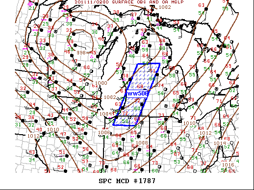
md 1787 concerning severe thunderstorm watch 506... for lower michigan...northern indiana
mesoscale discussion 1787
nws storm prediction center norman ok
0831 pm cst tue nov 10 2020
areas affected...lower michigan...northern indiana
concerning...severe thunderstorm watch 506...
valid 110231z - 110400z
the severe weather threat for severe thunderstorm watch 506
continues.
summary...severe threat will spread across the eastern portions of
ww506 over the next 1-2 hours.
discussion...latest water-vapor imagery continues to depict the
leading edge of large-scale forcing for ascent is spreading across
the central great lakes region. long-lived well-defined squall line
that developed over il has progressed across lm and currently
extends from northern lower mi-northwest in. this activity is
surging east at roughly 40kt and should exit the eastern edge of
ww506 within the next few hours. however, the strongest wind speeds
along the squall line have gradually decreased and should continue
to weaken as this convection spreads east tonight.
..darrow.. 11/11/2020
...please see www.spc.noaa.gov for graphic product...
attn...wfo...dtx...apx...iwx...grr...lot...
lat...lon 41338699 44158547 44158407 41348564 41338699
read more