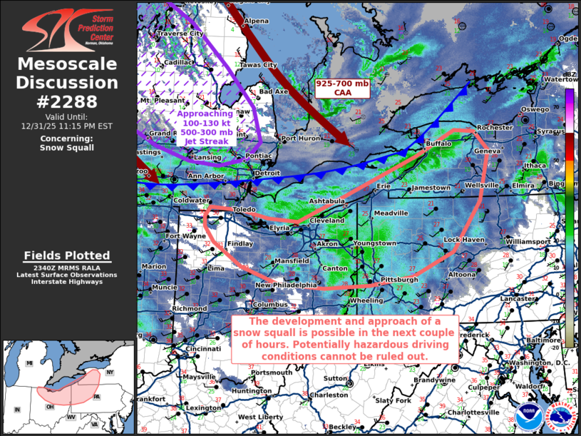
md 2288 concerning snow squall for portions of northern ohio...northwestern pennsylvania and southwestern new york
mesoscale discussion 2288
nws storm prediction center norman ok
0542 pm cst wed dec 31 2025
areas affected...portions of northern ohio...northwestern
pennsylvania and southwestern new york
concerning...snow squall
valid 312342z - 010415z
summary...a snow squall may develop in the next couple of hours, and
progress across portions of the ohio valley into the northern
appalachians through evening. a sudden onset of moderate to heavy
snow and 15-30 mph sustained northwesterly surface winds (with
higher gusts) will create hazardous driving conditions, including
reduced visibility.
discussion...a pronounced, strongly positively tilted mid-level
trough is amplifying across the great lakes and is progressing
toward the northeast. a 100-130 kt 500-300 mb jet streak is pivoting
around the upper trough and is poised to overspread the northern
appalachians over the next few hours. the approach of this jet
streak will dynamically enhance low-level lift along a
southeastward-moving surface cold front that is currently draped
over southern on to lower mi/southern wi. this aforementioned lift
will force a low-topped snow band along the surface cold front, amid
a sub-freezing troposphere in the next 1-3 hours.
while the synoptic pattern is generally favorable for snow squalls,
steep low-level lapse rates and accompanying instability is
currently lacking ahead of the cold front. nonetheless, strong
925-700 mb caa accompanying the mid/upper-level jet streak will aid
in the steepening of low-level lapse rates behind the cold frontal
snow band, which may result in just enough destabilization (albeit
very scant) to support a leading-line low-level circulation. should
a snow squall develop, a sudden onset of stronger northwesterly flow
(at least 15-30 mph, with higher gusts) may accompany portions of
the leading line, along with moderate to potentially heavy snowfall
rates. brief periods of appreciably reduced visibility may occur in
stronger portions of the snow band.
..squitieri.. 12/31/2025
...please see www.spc.noaa.gov for graphic product...
attn...wfo...bgm...buf...ctp...pbz...cle...dtx...iwx...
lat...lon 40438239 40738327 41168395 41448417 41628418 41798404
41738328 41618266 41558193 42028082 42747908 43207814
43187765 42837733 41927754 41017820 40577917 40428019
40358130 40438239
read more